Below are several news accounts of my son’s boat capsizing off the coast of Florida. And because he used a boating navigation app we develop called Pro Charts, I was able to alert the Coast Guard to his exact coordinates.
The core of the Pro Charts app is for boating navigation: marine charts, seeing depths, setting waypoints and routes, etc. But because Kevin and I had used the app’s “buddy” feature, I was able to see his location even though I was many miles away, safely at home.
How it works: You can invite family and friends to sync up with you via the app and they can see where you are on the water. It can be used for fun and — as in this case — it can be used for safety.
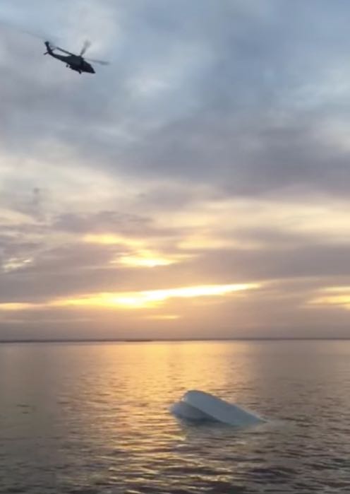
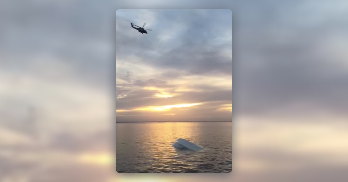
Coast Guard helicopter flies over Kevin’s capsized boat off the coast of Florida
While you can sync the Pro Charts app across all your iOS and Android tablets and phones, in this case it was on my son Kevin’s iPhone which also had a waterproof case. (Yet another reason why we highly recommend waterproof cases for your mobile devices.)
Read on below for the details of what happened and for a video Kevin shot from his waterproof-cased phone at the scene.
Father’s boater navigation app helps rescue son
Five men were duck hunting off Weeki Wachee last month when their boat capsized. Fortunately, they were found quickly thanks in part to the Pro Charts app one of the men’s fathers developed. “He called me frantically saying, ‘Dad, our boat sunk and we’re in the water,’ ” said Jay Stipe.
Potentially miles out in the Gulf of Mexico, Stipe’s 23-year-old son Kevin and his friends were in trouble.
“At that point I grabbed my app took a look at it and I could see him,” said Stipe. Stipe and his son were using an app he developed for his boat’s navigational system. From his home in Tampa, it gave him the exact coordinates to the location of his son’s waterproof iPhone. “He told me they were about three miles out and I looked at it and told him it looked like they were about one mile out,” said Stipe.
Stipe called the Coast Guard with his son’s coordinates. “He said that’s amazing because I didn’t know you could give lat long and coordinates. I said yeah I have that in my app and I can see where they are right now,” said Stipe.
A Fire Rescue boat and a Coast Guard helicopter found them at the same time. “He called me back about thirty minutes later and said we’ve got the boys everyone’s safe,” Stipe said. Stipe came up with the idea after trying to help search for two teens who disappeared off the east coast of Florida over the summer. “It was disturbing to me because no one could tell us where to initially look,” said Stipe.
Click here for boater safety info from FWC
That’s when Stipe made the connection between a social navigational app and search and rescue. “We can actually use this to save lives,” Stipe said. Stipe’s app stores the locations that also made easy to return to his son’s accident to retrieve lost gear. “They could have floated around there for a long time and gotten hypothermia and it could have been very dangerous for them,” said Stipe.
App aids in boaters’ rescue
New navigational phone application helps find lost mariners
By Abdon Sidibe – A story from Chronicle Online (Click Here to see the original story)
Thursday, January 14, 2016 at 7:43 pm
It is a navigational tool born out of tragedy, but in an ironic twist of fate, the first lives it helped save included the son of the Tampa businessman who created it.
Hunters aboard a Citrus County Sheriff’s Fire Rescue boat watch as a U.S. Coast Guard helicopter approaches their sunken vessel in Chassahowitzka Bay.
Jay Stipe, president of MiraTrex Inc., had just developed a GPS-driven boater navigational app, which can be loaded on an iPhone or iPad, as a reaction the tragedy during which two young mariners were lost on the east coast of the state. The remains of the young boys were never recovered. However, Stipe said if only the boys had his app called PRO CHARTS, things might have been a little different. “As a parent, that incident broke my heart,” Stipe said. “I kept thinking if there was an app that would have plotted the real coordinates of where the boys were, rescuers could have gotten to them quicker,” he said.
Soon after Stipe worked on the notion and developed the app, his 23-year-old son Kevin and four of his friends set out to go duck hunting in the salt flats off the Hernando/Citrus county line near Weeki Wachee on Dec. 22. The five men were riding in a Mako, 17-foot boat, around 4 a.m., when the boat started to rapidly take on water in pitch-black conditions with water temperatures in the mid-60s. Kevin said the group struggled to figure out why the boat was taking on water and decided to shed gear including their rifles to maintain buoyancy. “Then the boat suddenly capsized. My friends’ phones were in the water. I still had mine up high and it had a water-seal case,” Kevin said. He said he called the U.S. Coast Guard in St. Petersburg and they said they were dispatching a helicopter, but it would take about an hour and a half before they could there. He also told them they were about three miles out in the Gulf.
Kevin’s next call — to his father — proved to be critical. Shivering, cold and hanging onto the capsized boat, in about 8 feet of water, Kevin called his dad and explained their predicament and asked him to call 911 to supply the coordinates of their location using the new navigational app his father had just developed. “I hung up with Kevin, got out of bed, and went downstairs to get my iPad. With the Buddies feature in PRO CHARTS, I was able to view his location on screen and I saw that he was actually about one mile out from the marsh flats, not three miles. I took a screenshot to capture where he was in case the signal was lost,” Stipe said.
He supplied the coordinates to rescuers and the Citrus County Fire Department was first on the scene, followed shortly thereafter by a Coast Guard Apache helicopter. The men were rescued, but the group wanted to salvage their gear, including the rifles. Jay Stipe again used the app’s memory feature to return to the exact location and the group was able to recover a lot their gear, except for four rifles.
“It was a scary situation. If we didn’t have this app, it could have ended pretty bad,” Kevin said.
For information about the app, go to miratrex.com. The app costs $2.99 a month.
New ‘Buddy’ Feature on Navigation App Could Save Your Life
When designing the new “Buddy” feature for the PRO CHARTS marine navigation app, MiraTrex president Jay Stripe had no idea it would potentially save his own son’s life.
“On Tuesday, December 22, 2015 my son Kevin and four friends decided to go duck hunting near Weeki Wachee,” Stripe says in a press release. “Around 6:00 in the morning, I awoke to a frantic phone call from Kevin saying the 17’ Mako boat they were in had capsized and they were in the water needing help. Thankfully, Kevin keeps his iPhone in a waterproof LifeProof case so his phone worked and he was able to make calls. The other boys’ phones were all lost when the boat overturned. Kevin also had our PRO CHARTS app installed on his phone which he was using to navigate to their hunting spot on the salt flats about 5 miles North of the Weeki Wachee River.”
Through the “Buddy” feature on PRO CHARTS, which allows you to track the exact coordinates of your buddies, Stripe was able to pass the latitude and longitude of his son’s location to the Coast Guard. By 7:53 a.m., Stripe’s son and his friends were in a rescue boat.
The PRO CHART app allows you to monitor not only your buddy’s current location, but also their location history for the previous 48 hours. That way, Stripe’s son and his friends were able to return to where they capsized and retrieve their lost fishing gear. The app also has a feature that lets you type up and email your float plan to friends and family.
The PRO CHARTS app is compatible with iPhone, iPad, and iPod touch, and can be purchased from the iTunes store for $2.99/month or $29.99/year.
Boating Tragedy (Duckworksmagazine.com)
by Jay Stipe – Florida – USA
December 24, 2015
As a result of the tragedy in July when two young boys were lost at sea off the East coast of Florida, my company, MiraTrex, Inc. added a new “Buddies” feature to our PRO CHARTST marine navigation app in an attempt to help prevent similar tragedies in the future. As the president of MiraTrex, I never would have imagined that my own son would be one of first people ever to be rescued using our app.
On Tuesday, December 22, 2015 my son Kevin and four friends decided to go duck hunting near Weeki Wachee. Around 6:00 in the morning, I awoke to a frantic phone call from Kevin saying the 17′ Mako boat they were in had capsized and they were in the water needing help. Thankfully, Kevin keeps his iPhone in a waterproof LifeProofT case so his phone worked and he was able to make calls. The other boys’ phones were all lost when the boat overturned. Kevin also had our PRO CHARTS app installed on his phone which he was using to navigate to their hunting spot on the salt flats about five miles North of the Weeki Wachee River.
When Kevin first called me, he said they were about three miles offshore in about 6′ deep water and he had already spoken with the Coast Guard who told him they were sending a helicopter. While the situation may not have been quite as urgent in the summertime, the water was only 66 degrees that morning and the boys were at risk of hypothermia if they stayed in the water too long.
I hung up with Kevin, got out of bed, and went downstairs to get my iPad. With the Buddies feature in PRO CHARTS, I was able to view his location on screen and I saw that he was actually about one mile out from the marsh flats, not three miles. I took a screenshot to capture where he was in case the signal was lost. I called Kevin and told him his correct location, but before he could answer, the call was disconnected. He then texted me and said to call 911 and give them the correct location.
When I called 911, the dispatcher told me they were aware of the situation, but they wanted me to contact the St. Pete Coast Guard who was coordinating the rescue. I called the number provided and spoke to a Petty Officer Matt (I don’t recall his last name). I told Matt I had an updated position for the capsized boat and he replied, “Go with the numbers.” I read off the coordinates to him and he said, “How are you able to give me the exact coordinates? Are you using Find iPhone or something? I didn’t know you could get lat lon numbers with that.”
I replied, “Yeah, something like that. I have a company that makes a marine navigation app that allows you to see other users and their location history with a feature that’s like Find Friends.” He said, “So you know his exact coordinates? Wow, that’s a great app! We’ve got a Citrus County Fire Rescue boat putting in now and a helicopter taking off in five minutes. I’ll call you back when they’re on station.”
I continued texting with Kevin and he told me they were holding on to the bottom of the capsized boat and all their hunting gear was gone. I asked if he could dive down and find anything, but he said, “No, it’s still dark and we’re drifting.”
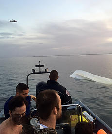
At 7:53am, he texted me this picture of them in a rescue boat with the sunk Mako and helicopter in the background.
A few minutes later, I received a call from Petty Officer Matt saying the Citrus County Fire Rescue boat picked the boys up simultaneous to the helicopter arriving on scene. He said they were all safe and he was pleased to tell me it was a successful rescue. I thanked him and we wished each other a Merry Christmas.
After the boys were taken back to the dock at Weeki Wachee, we talked about how to go back to salvage the boat and try to recover the lost gear. I told Kevin I still had his location history so I could see where they stopped and then started drifting. In addition to displaying an icon of a buddy’s position on-screen, our app allows you to touch the icon and bring up your buddy’s current location and their location history for the previous 48 hours.
I texted Kevin the list of coordinates. After an extensive debrief with FWC and no small amount of paperwork, the boys were finally able to head back out on borrowed boat later in the afternoon. The plan was to right the capsized boat and tow it around to bail enough water so it would float again. It soon became clear this wasn’t possible so the boys instead turned their focus to retrieving their lost gear.
Unfortunately, they couldn’t just pick one point and say that’s where the boat overturned. If Kevin had thought about it at the time, he could have touched the Mark button in our app when they first went down which would have provided the exact location, but when your boat is going down in the dark and your body hits the cold water, that’s not something you think about at the time. So instead of having an exact location to work with, they had to go by the series of marked locations to identify a path to search. Nevertheless, it worked great and within an hour or so, the boys were able to find most of their lost gear.
Finding the gear was nice, but the far more important part of this event is that all five boys came home safely. I also couldn’t be happier that our app worked as intended and helped in the rescue effort. I never anticipated it would also be essential in the search and recovery effort after the fact. We designed the buddies feature to record a buddy’s location history so you see where he was heading when the signal was lost. This feature was added as a direct result of the two boys that were lost at sea in July. Our thought was that if you could see the track of where they were heading, you might be able to narrow down an initial search area. It never occurred to me that the location history would also be useful in recovering lost gear.
There are certainly several safe boating lessons to be learned by the boys as a result of this event. In particular, it’s critical to always verify the seaworthiness of your boat before heading out. Apparently, one of the baitwell valves was left in the wrong position which caused it to overflow onto the deck and leak down into the bilge through a hatch that wasn’t closed properly. In the day, this probably would have been noticeable, but they didn’t see the overflowing baitwell or the open hatch in the dark since they left the dock around 4am that morning.
There are also a couple other less-obvious points that all boaters might want to consider. In particular, this whole episode could have possibly ended in tragedy if Kevin hadn’t had his iPhone in a waterproof case. They were only in about 6′ deep water, but it was dark and the water was cold. Some of the boys were wearing waders which instantly filled with water and made it impossible to swim. They had a VHF radio on the boat, but it was lost as soon as the boat overturned. Without a working cell phone to notify someone about the emergency, it could have been many hours before anyone even realized they were missing.
If you think about it, a waterproof iPhone case potentially saved these boys’ lives. Panel-mounted GPS equipment, flares, a whistle, and a VHF radio are normally essential tools in an emergency, but if a boat sinks quickly and capsizes before you can get to them, they’re all useless. I’m not suggesting anyone should replace any standard electronics or safety equipment, but having the ability to call someone and identify your position with a marine navigation app is extraordinarily important as a backup. Of course, I’d love it if everyone used PRO CHARTS since my company offers it, but there are several marine navigation apps currently on the market. However, at the moment, ours is the only marine app with a buddies feature that allows you to see other people and view their recent location history.
One final note about safety is the importance of filing a float plan before you head out so someone knows where you’re going and when you’re expected to be back. This can be as easy as verbally telling someone or sending an email, but you need to be in the habit of actually doing it. We have a Float Plan feature in PRO CHARTS that makes it as easy as simply clicking a button to email your intended route to a friend or family member.
It takes less than 10 seconds to do, but you can’t forget to do it. Kevin didn’t send me float plan for his duck hunting trip so I had no idea where he was going or when he expected to be back. We’ll definitely talk about that to make sure he sends a float plan before heading out from now on!
12/30/15 Update: I just learned about country singer Craig Strickland who is lost and feared dead along with a friend after their boat capsized in a storm while duck hunting on Kaw Lake in Oklahoma. This is another tragedy that may have been avoided if they simply had a cell phone in a waterproof case and our app so someone could see their location. These are two very similar events that started out with a recreational day of duck hunting that turned bad quickly. Sadly, one of them ended in tragedy while the other was a successful rescue story. My hope is that we can spread the word and prevent similar tragedies in the future and turn them into rescues as well.
View original article here:
duckworksmagazine.com